Wednesday 12 September 2012

August 23, 2012….P.C. (Post Computer)

Well it happened last night; I was kind of expecting it would...... I was out voted 9 to 2 in favor, so after dinner it off to the shower. A clean new man in the same dirty clothes!  Oh ya, my computer died. We think it has a virus, but we cannot even start it to run a scan. 5 minutes at a rolling boil should destroy various pathogens such as viruses, although I might have a tough time explaining that to the IT Department. Anyhow I’ll keep notes in a field book until I can transcribe them.
Today looks like it could be another day in camp. The fog is low in the valley and the rain is coming down in buckets. Our chopper pilot, Brian, said that he is willing to fly the water sampling crew out to collect their samples, as he can fly the river the 12 miles necessary to reach site Mile 184 (I can just picture the scene from “Apocalypse Now” where the choppers come in low just above the water with “the flight of the Valkyries” playing on the loud speakers) and stay with the crew until the work is completed of the weather changes.
Charles “Chuck” Gravelle the project field manager is still playing e-mail tag with the crew back home, they keep changing the program. 1st it’s 6 sites in 4 weeks , then if we finish the required (6) sites early, we go home early, no wait…another change we finish the required (6) sites early, they add 6 more sites and cut the time frame, no wait it’s changing again…same time frame, add the 6 new sites but make them at the far end of the trail (0-100 mile range from Norman wells while we are at the 170 mile mark, increasing out travel time to and from the sites. We have t fly the chopper there and back twice just to move crew and then again for equipment = 3 flights in, 3 flights out) all the time complaining about the amount of chopper time and fuel we are using. One of the sites is a small drum cache on June Lake, tucked back deep into the Skewi Range of the Mountains. None of us has been to this site before so we have no idea what to expect.
But for today we will sit quietly in our cabins reading or in the dinning tent drinking coffee and playing cards, some will work on their computers and others will go from cabin to cabin chatting and stoking the fires to drive the dampness out. It’s going to be a long day.
1000h and time is moving a glacial speed. We’ve chatted all morning about all the places we’ve worked and the times we’ve had in camp.
1100h, I have some work to do…plotting the locations of the sites on a Nav. Chart. It should do me until noon!
1200h – lunch – homemade chicken soup. We are starting to get a little concerned for the welfare of our field crew, we have not heard from them since they left after breakfast and the weather shows no signs of improvements. Well back to cribbage and teaching the drillers how to play so that we can have some variety in players.
1300h, the day feels like it’s dragged on into weeks…..time to put a fire in the cabin and have an much needed afternoon snooze.
Unfortunately my photos are all on Chuck’s computer so I load them as soon as I can them.
1500h we made an attempt to get into Mile 108 and Mile 111.4 to complete the work. We flew mid-mountain height into the sites to complete the required work of water sampling and surveying. On the way home we flew the river to check on the condition of a German hiker that passed through Ram’s Head a day or two earlier, he was traveling alone and with no sat-phone or GPS communicator, and as the weather was not improving and this was going to be our last trip in this direction of the trail for a week, we thought it would be a good idea to see if he was ok. Well we found his camp partially set up on the trail and him sitting in the woods taking care of business…..
 As the acid smoke from the black spruce logs that are burning in our stove, stings the inside of my nose, and the snoring from my two roommates rattles in my ears, I lie in bed trying to read by the fading light of my flashlight. My bed if you can call it that…my bed is of the Canol Trail vintage and probably came from mile 180 and has one leg shorter that the rest, regardless of which one I try to shim. The springs offer all the support of a “slinky” and regardless of where I sit I sink to within inches of the floor. I did manage to grab at 2 foot by 6 foot long piece of plywood to put length wise along the top of the springs with a second piece 2 foot long by 1 ½ foot wide across the middle of the bed. The third piece was 2 feet by 2 feet and placed to add support for my head (in theory). I have 2 foam mattresses, so thin that you can almost see through, that will not stay stacked regardless what I do. It’s like trying to get two same poll magnets to stick together. My sleeping bag, oh yes my wonderful, magnificent sleeping bag. The Woods Muskoka model (good to -35o) is likely one of the best purchases I have ever made. I slept like a baby, warm and comfortable albeit a little crooked.   
Cheers

Thursday 6 September 2012

Contwoyto Lake Photos

And here are some from Contwoyoto Lake.


Our site as seen from the window of the twin. It includes all that you can see and then more tundra off on the sight. The site is an island and is used by hunters today and I believe that there is some historic use (not necessarily ancient) as is evident by the amount of animal bones observed. The site is also frequented by bears and wolves.

The hunters cabin, this trip the twin stayed with us.


Trophies left to bleach in the arctic sun.

A few flies come for lunch! Chuck is on the menu.

A view from the point towards the weather station (way in the background), drums, drums and more drums. I’m at the point where I don’t consider it a drum cashe unless it has 100 or more drums in it.


Claire as co-pilot.


The second twin on contwoyto Lake.


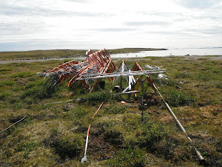
The old radio tower.

The weather station.

Kelley Kettle on the shores of Contwoyto.

How clear and cold the water is.


Looking across the tundra. It's hard to keep it in perspective; there is nothing to define the boundaries.


And lastly the scariest animal in the arctic…..the cariBOO!


Photos from Copper Pass

Here are some of the photos from copper pass that I could not load when in Yellowknife.

The prospectors cabin, and our shelter in the event that the twin otter does not return.

Claire hard at work collecting a waste rock sample.


The main showing, trench # 1 (from the hill top)

Closer view of trench # 1

The Main showing trench # 2 (from the hill top)


Closer view of trench # 2
 (that's me going inside to take gamma readings and to measure the depth of the water)


This shot sort of covers the main body of the site. the camp (where the plane lands) is in the center middle on the point of land, the main showing is straight up on the right (under the edge of the engine cover), the west showing is on the far right, middle, where the two points of land meet. the "Pond Area" is near the exhaust of the engine if on the backside of the small pond. there were several small trenches in this area. And the east showing is off shot to the left of the pond area. our days started with landing at the camp and then walking up-hill through the woods and marshes to the area we were inspecting that day and then tracing our way back to the camp to await the arrival of the twin.

The west showing.


My best "Weirton Willy" impression.


General site conditions.

Blasting caps, on the left - spent, on the right - live or dud, that is the question?

Our Crew, you would be hardpressed to find a finer bunch of people to work with.


August 22, 2012…..Day 12, feels like day 40!

Today was a fill in the blanks day, our drillers got to have the day off, they spent the day sleeping in, playing card games and going fishing. I’m in the wrong business.
As for us we got off to a late due to being fogged in, however we were in the air by 0710h (instead of 0700h) flying under the fog at 500ft. it was a 4.5 minute flight back to the first site we were at (Mile 170) to pick up items that we had missed or put off on the first visit. James and I worked on the leveling survey while Claire and Julie completed the DGSP (digital GPS survey of the boreholes and monitoring wells), water levels and water sampling.  By 1030h we lifted off for Mile 131.4, after 15 minutes of flying down the valley (the fog was still below the mountain tops) we hit the fog full on and had to turn around and head back to Ram’s Head camp. It was almost 1500h before we left camp for Mile 131.4 with the same crew as before, doing the same work.
The first attempt to reach the site at Mile 131.4.
While we were fogged in,  I managed to sneak a peek into the camp kitchen and grab a photo of the stove that I would like to put in the kitchen at home…..well what do you think Shelly?
The dog on the floor is NOT dinner, she is just playing dead.
 This is Pipper, she is the puppy of the bunch at camp, there are 4 Australian Sheppard, who keep the horses in line and guard the camp from all sorts of dangers ie. Bears, moose, sheep, caribou and sic-sic. The cat, Travis, keeps us save from all things feathered.
The washing machine we get to use for cleaning our field clothing, wash, wring out, hang on the line..repeat.
Well my luck with computers is running out, this is the longest I’ve ever gone without running into some type of computer error, today the computer, henceforth to be known as “Brick” has started acting up and keeps asking me to “insert system disk” and will not recognise the C or D drives. I will continue to write down what transpires here in my field book and transcribe the notes when the “Brick” is working again, likely not until I return home sometime in September….
I’ll leave this now in peace and put pencil to paper.
Cheers….


THANKS TASH

I would like to take this opportunity to thank my sister-in-law Natasha for all the hard work she has done to make these posts possible. She has been taking pdf formats of the posts that I e-mail to her and then posting them on my behalf. You’re the best! (next to Shelly that is)
August 21, 2012
Today we were working at Mile 80. The site is on top of the “Planes of Abraham” a windswept plateau in the middle of nowhere. The site has a few small building left standing, several vehicles that need more than a little work and several small garbage dumps. We were on this site to investigate the large oil spill that took place there back in the 40’s.

An aerial view of the site from the A-Star on our way in, the reported oil spill was at the bottom of the hill (center, middle of the photo).

A view looking down the valley from the site. This land is so big!
One of the remaining buildings left on the site.
A two stage Canol snow blower in need of a tune-up
Canol vintage junk, fuel cans, food cans and miscellaneous debris.
Junk left by some professor who was doing his thesis on the impact of oil on the natural environment, but who apparently does not believe in the rule “pack it in, pack it out” now we not only have to clean up the rubbish left by the US Army and the hikers (who also leave garbage on the trail and in the buildings) but also by the ones who are studying the environmental impacts on the Canol Trail.
On the way home we passing a localized storm.
And another one…..
And another one……there were 5 in a 20 minute flight.
A small mountain lake, the colour is an amazing blue (see the storm in the background).
Cheers from up in the north….