Monday, 5 August 2013

The Town of Norman Wells.

A few photos from around town…..
 
The public works yard

 
The Royal Canadian Legion, Canol Branch 287.

 
The Canol Heritage Museum.

 
The golf course.


Looking down the 1st. fairway.

 
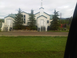
The Church.

 
The fire hall.

 
The medical building.

 
The dential office.

 
The town offices.

 
The day care.

 
Canadian North, my ride home.

Saturday, 3 August 2013

July 29 Canol Trail Day 6 (the end of another sortie on the Canol)

Today we fly! It’s just a matter of when. The sky over the Wells is clear, however there is a low cloud bank covering the mountains and as we are flying VFR (visual flight rules) it is kinds nice to see what we are flying into.

We headed out for Mile 50. Another beautiful place on the Little Keele River.


The rapids.
 
Some massive bulldozer blades.
A caboose, these are the bunk houses that the workers slept in. they are mounted on huge wooden skids and were pulled from one work place to another.
On old Studebaker engine
Form there we moved on to Mile 108, up on the plateau near Devil’s Pass. This was Pump station 4 of the pipeline. The weather was fine when we landed, however by the time we were ready to leave we were in the middle of a downpour. We got wet!
Up and over "The Pass"
The site sits in a beautiful valley.
 
The power building (in the foreground) and the Pumphouse (in the background).
 

Tea time with the Kelly Kettle at Mile 108.
 
Then moving up the trail to Mile 131, a small camp and 131.3 is the location of one of the spill sites I visited on my last trip on the Canol. The weather here cleared up for a few minutes, then we were hit by a micro-burst. We got wetter, soaked through the rain suit to the skin.


A few shots of the Canol Trail.
 
Arriving at Mile 131/131.3. Mile 131 is the location of the camp, there are several cabooses, most of which are in very poor condition.
 
A view of the river bank and the incoming weather front.
 
And here comes the rain - again!
 
A quick stop at Ram’s Head for fuel for the chopper. While there we met some hunters who were on their way home after a successful hunt. The sky starting to clear, we are starting to dry.


We then finished the work day with a landing at Mile 202 to ground proof what we had seen during our flyover from the other day. Still drying out, with the windows open on the chopper it’s like being in a dryer.
Mile 202 is down there on the river bank.
Another old truck up on blocks.
 
This is one of the wooden skids that i had mentioned earlier.
 

The 1 ½ hour flight back to the Wells was a rough one as we flew through one storm after another. By the time we landed we were completely dried out, until we got out of the chopper to unload our samples and equipment, another micro- burst, wet again.

Tomorrow we fly back to Yellowknife if we can get a flight however there is still lots of packing and shipping of samples and equipment to be done before we fly. It could be a late night and an early morning.

I wish to thank the ground crew and our pilot, Devin, at Canadian Helicopters in Norman Wells for providing excellent service both in the air and on the ground.

I would also like to thank our wildlife monitor, Cody, for all the help and information he provided us.
Cheers.

Tuesday, 30 July 2013

July 28 –Canol Trail Day 5 - Sort of!

Today was another “no-fly” day. I was able to work on another project, a Designated Substance Survey, and Building Material Inventory and as luck would have it, it was here in Norman Wells. It was only a small building and only took a couple of hours.

We are hoping to fly into the mountains tomorrow and complete out work here.
 
The norman Wells Airport sign.


Very cool street signs.

 
Cheers from the Wells.

Sunday, 28 July 2013

July 27 – The Canol Trail Day 4


We finally made it into the mountains and on to the Canol Trail.
Crossing the Mackenzie River.
The Dodo Canyon.
The Twitya River meeting the Keele River.
Storm clouds over the mountains.
We started our work at Mile 170, working in the rain. None of the wells that we checked had water and the only well that we expected to have water was destroyed by a bear.
Mile 170 in the rain, Ekwi river in the background.
 As the rain had soaked all of us through to the skin and we needed fuel for the chopper we headed to Ram’s Head (this is one of my favorite places) Stan, Debbie and Bailey welcomed us to the hearth with hot coffee and fresh homemade cookies.
Ram’s Head Lodge.
Looking down (towards the Norman Wells end) the valley.
 Re-fueled, both us and the chopper, we headed for Mile 142. We spent several house working here, as all the wells produced water.
Mile 142, The Canol Trail.
As we were lifting off there was a single mountain that caught my attention, it was beautiful, so I decided  to name it, Thomas Mountain and it is located at N64o13’30”, W128o25’00” (might be off by a little as I was locating it from the chopper). 


Map showing the location of Thomas Mountain.
Thomas Mountain.
At 1600h we packed up and prepared to head to Mile 131 & 131.3, however as the sky had cleared and we could see the mountain tops we decided to make a run for the far end of the trail and go for Mile 225.2.
At 1710h we arrived at Mile 225.2 (all wells dry),
Chopper on top of the hill.
from there we worked our way back to Mile 224.6 (again all wells dry),
Chopper in the willows.
on to Mile 222.5 (this site we did manage to collect some water samples),
Ranger station.

Canol Trail sign.
and then to Mile 208. No wells to sample here however we had to check the buildings for drain pipes and conduct an assessment of the creek bed. By this time we had gone over our flight plan (this means that we should have been on the ground at the chopper hanger (208 miles away) as we had reached the hour that was filed as the end of day).
The camp.
The kitchen (used by hikers and hunters alike, for shelter).
The pump house.
The NWT sign on the pump house.
Another hope to Mile 202 (it’s on our way home) no landing required,
Mile 202.
just some air photos and notes then the hour and a half flight to the base. Most of the flight back we were racing a storm front. All said and done the samples were in the fridge and we had dinner 2300h.
This is my third trip to the Canol Trail and I don’t know how many hours I have logged in the choppers flying through the mountains, but what I can say is “wow” (said in a respectful whisper). There is no way for me to convey the awesome beauty that I have seen, so all I’ll do is add some photos.
Glacier on a mountain top.


Mt. Keele, in the Yukon.


The storm front we raced home to Norman Wells.


Cheers from the Astar BA, over the Land